- Distance: 110 kilometers (68 miles)
- Time: 6-10 days
- Difficulty: Challenging (steep climbs, uneven terrain, variable weather)
- Start/End: Laguna Amarga ranger station or Refugio Lago Pehoe
- Season: November to March
We completed the 8-day O Circuit through Torres Del Paine in February 2024, and while we spent the months leading up to the start of this journey reading as much as we could to be prepared, there were still so many things we learned along the way that we thought could be helpful to others considering this spectacular trek. Below, you’ll find our experiences from each day, along with some extra tips that may help you plan your own trip. If there’s anything you take away from this blog, let it be that if you have the time and capacity, commit to the O circuit rather than just the W. The portion of the trek that is the O was the most memorable of our time in the park, and we couldn’t be happier that we chose this option over the W. Hopefully, we can convince you of this as well.
Day 1: Entrance to Seron Campsite
Our adventure began early with a 7am bus departure from Puerto Natales, arriving at the park entrance (Laguna Amarga stop) by 9am. After an hour’s wait for the Los Torres shuttle, which brought us to the visitor’s entrance (and the start of the trail), along with a $4000 peso shuttle fee per person (note: at the time this was written, the shuttle fee could only be paid in cash), we proceeded to the Seron campsite. The trailhead was not immediately obvious from the visitor center, but following the path to the right led us in the right direction.
The first day’s hike covered 13 km and took about 4 hours, including navigating through a few confusing trail forks. Our AllTrails app proved invaluable in keeping us on the right path. Although the scenery was beautiful, it paled in comparison to what we would see in the days ahead. Day 1 felt surprisingly strenuous, likely due to getting used to carrying our pack and the added challenge of carrying eight days’ worth of food.
The campsite offered hot showers and paid Wi-Fi, but the cooking facilities were limited, and the windy conditions at night necessitated choosing a sheltered tent spot. Note that check-in for this campsite isn’t until 2:30 pm, so pacing ourselves to minimize waiting was important. In hindsight, taking a later bus from Puerto Natales could have helped us avoid the long line for the shuttle and allowed us to arrive at the camp after the check-in time.
Highlights: The scenic valley and Rio Paine vistas.
Challenges: Long wait in line for the shuttle (this can be avoided if you want to walk the extra 7km to the visitor’s center); adjusting to the weight of a heavily packed backpack.
Day 2: Seron Campsite to Dickson Campsite
Day 2 began on mostly flat terrain, leading up to a small but steep pass where we battled intense winds that persisted while we were out of the tree line. A checkpoint halfway offered an opportunity for a snack and a mandatory inspection of our reservations. If you do not have the required booking, they will turn you around to hike back to the start.
From there, it was a flat 10 km journey to Dickson, with the trail providing spectacular views of snow-capped mountains and occasional glimpses of the towers. The descent into Dickson offered a breathtaking view of the campground and lake, marking the end of a day during which we ascended 2234 feet and descended 2139 feet, taking us 5 hours and 17 minutes.
The Dickson campsite was a highlight, featuring a lively atmosphere, abundant food, and supply options, including beer, sodas, and snacks. Hot showers are available, though water pressure decreases when used simultaneously. Wi-Fi is available for 8000 pesos per hour. The campsites here offer more shelter than those at Seron, especially if you can snag one amongst the trees.
Highlights: The picturesque (and flat) second half; mountainous landscapes.
Challenges: The early pass and the subsequent relentless winds.
Day 3: Dickson Campsite to Los Perros Campsite
The third day covered 12 km from Dickson to Los Perros, starting with a series of inclines but eventually leveling out. Despite its reputation as an “easy” day, the distance felt substantial. The final two kilometers before Los Perros were particularly memorable, featuring a bridge crossing that offered the first views of the Los Perros glacier.
The Los Perros campsite was the most basic we encountered, offering no on-site food purchases outside of prebooked meals and no Wi-Fi, and it was noticeably colder there. For convenience the next morning, we opted to rent a tent (28000 pesos) and sleeping pads (8000 pesos each), rather than setting up our own gear.
Unlike the W portion of the trek, we discovered that the campsites on the O circuit had several extra tents available for rent, facilitating last-minute changes. This might not have been possible at the W campsites without paying a premium (see Day 6).
Highlights: The Los Perros Glacier
Challenges: The initial climb leaving Dickson
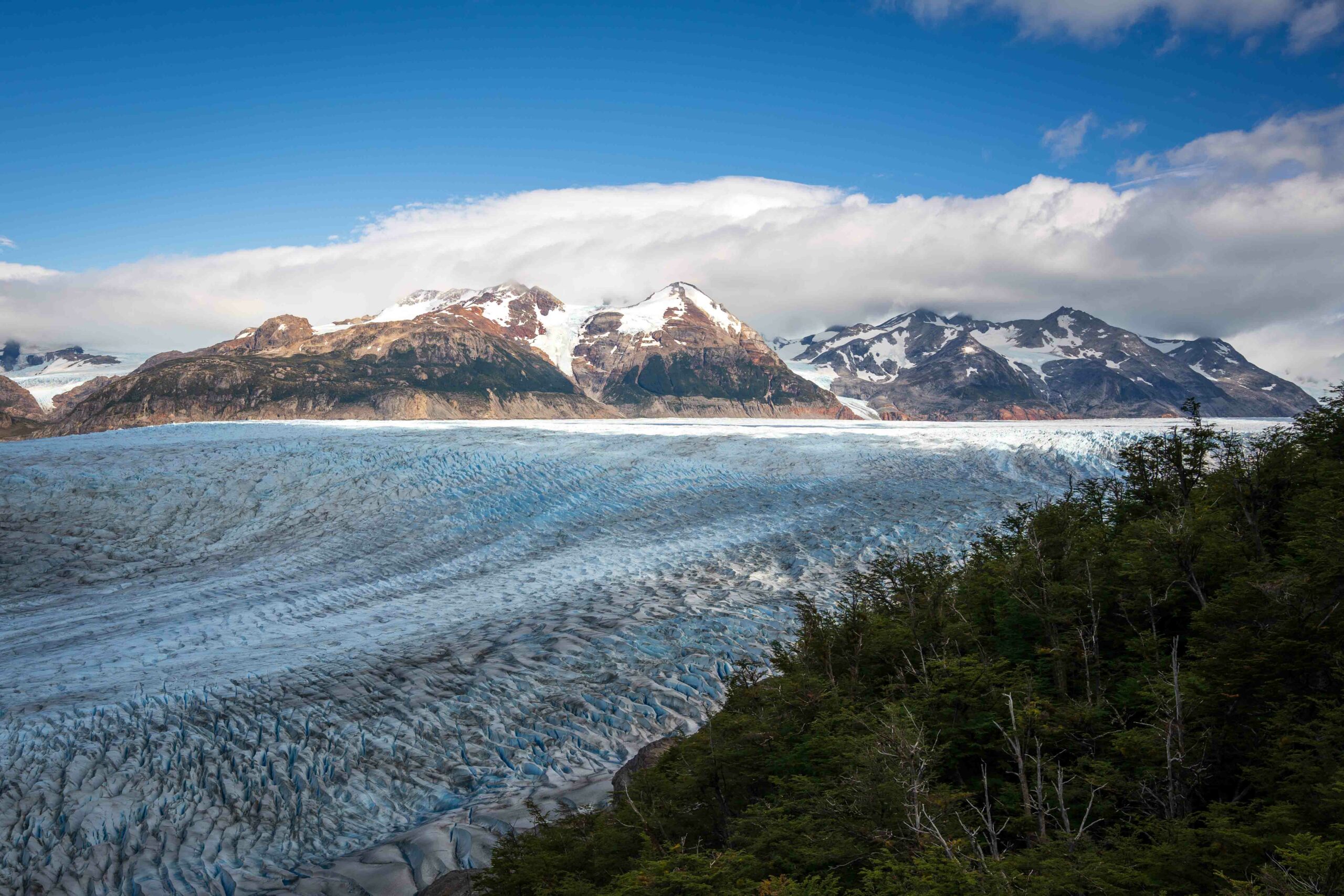
Day 4: Los Perros Campsite to Grey Campsite
Day 4 of the O trek, from Los Perros to Grey camp, featured the famous John Gardner Pass. We woke up early at 4:30 am (unintentionally, due to surrounding noise) and, after a quick breakfast, began our hike at 6 am. The path to the pass was muddy and required balancing on logs, made a bit more challenging with only the light of our headlamps.
The pass, filled with switchbacks and windy open areas, wasn’t as daunting as we anticipated, but there were moments when it seemed to take forever to reach the top. We arrived at the pass around 8:30 am, but the time it takes to get there can vary based on fitness levels. The views from the pass were absolutely epic, and we spent about 20 minutes there taking photos. This view, earned by the hard work of climbing the pass, is why one should do the O circuit; it’s incredibly rewarding. Everyone we were with agreed that we were incredibly lucky with the weather, as it could have been raining, hailing, or extremely windy, instead of the sunshine and mostly reasonable winds we experienced.
Descending from the pass, we faced a long and steep decline that was tough on the knees. The checkpoint, further than expected, wasn’t ideal for lunch due to bugs; however, we found a much better spot with a view just a few minutes away. The route featured three suspension bridges, including a notable 150m climb after the first, and had some sketchy drop-offs that required careful attention. After the second bridge, we began to encounter day trekkers coming from the opposite direction for the first time in 4 days. The day took us 7 hours and 38 minutes, covering 2900 feet of ascent and 4511 feet of descent, and we had never been happier to reach camp.
The Grey campground was well-equipped (hot showers, Wi-Fi, stocked store), and we enjoyed sunset on a nice beach on Grey Lake, just a 10-minute walk from camp.
Highlights: The epic Grey Glacier view from John Gardner Pass.
Challenges: Navigating the pass and managing a steep, knee-straining descent.
Day 5: Grey Camp to Paine Grande Camp
Starting later at 9am due to the day’s shorter distance, we savored the last views of Grey Glacier behind us along the way. The path featured lots of open spaces without shade, making head coverings and sunscreen essential. The 11km journey took us about 3 and a half hours, with a few stops along the way.
This campsite boasted the largest kitchen space we’d seen yet, with a large area for cooking and plenty of tables, adjoined by a large dining room and a separate bar upstairs. The food offerings in the bar were similar to those at Grey, including burgers and pizza. Also, like Grey, this campsite has a large store where you can buy food supplies, beers, and toiletries, as well as a few souvenirs.
As this campsite is where many of the W trekkers catch the ferry back across Pehoe Lake, there are a lot of people coming and going all day.
Highlights: The lingering Grey Glacier vistas.
Challenges: The absence of shade across the open terrain.
Day 6: Paine Grande to Francis/ Los Cuernos Camp
Our hike from Paine Grande to Los Cuernos Camp took 4 hours and 52 minutes, including a stop at Francis, with an ascent of 1453 feet and a descent of 1371 feet. Rain marred the trek, dampening our spirits somewhat on the way to Francis. Francis Camp, nestled in the forest on a hill, required some trekking up and down to access the kitchen and camping spots, all of which are positioned on platforms.
Initially, we were booked to stay at Francis, but persistent rain disrupted our plans to visit Mirador Britanico, leading us to arrive at the camp too early, around 10:30 am. The cold weather and altered plans prompted us to switch our reservation to Los Cuernos and proceed an additional 5 km to the next camp. Due to the last-minute change, we had to settle for what was available at Los Cuernos camp, which, in this case, was a tent already set up, incurring an extra cost. Keep in mind that the flexibility we experienced might not always be possible, especially on the more popular W trail compared to the O side.
Our friends who stayed at Francis reported mixed experiences with the hot water in the showers, although they appreciated the private shower rooms as an improvement over previous accommodations. On the next trail section to Los Cuernos, we were treated to stunning views of Nordernskjold Lake, including a memorable path along the lake on a rocky beach, ideal for a snack break. Los Cuernos camp boasted a cozy, ski lodge atmosphere, complete with beer on tap, and offered beautiful views of the Cuernos del Paine mountains, with a waterfall in the backdrop.
Snack options were limited, available only for purchase at the reception desk and the bar. The bathrooms and showers, showing signs of wear, were not the cleanest but offered reliable hot water and pressure. Ultimately, Los Cuernos ranked as one of our favorite campsites, second only to Dickson and Grey.
Highlights: The breathtaking lake views en route to Los Cuernos.
Challenges: The inclement weather and trail conditions.
Day 7: Los Cuernos Camp to Chileno Camp/ Mirador de Los Torres
Our journey from Los Cuernos to Chileno Camp lasted 3 hours and 25 minutes, involving an ascent of 2182 feet and a descent of 1138 feet. The path to the fork leading to Chileno had gradual ups and downs, making it relatively easy to navigate. However, beyond the fork towards Chileno, the trail became much steeper, posing a challenge, particularly with the full weight of our packs.
Chileno was the busiest camp we encountered, highlighting the importance of placing food orders early. Unfortunately, by the time we returned from climbing the towers, meals and individual food items were sold out, likely due to the influx of day hikers and others arriving from Central to hike and then stay for drinks. There were no lockers for storing our packs, and since we arrived before check-in, we couldn’t access our tent. We secured our bags as best as we could and hung them on a camp wall, while many others left theirs in a pile.
Before check-in, the campground’s bathroom was closed, directing everyone to the restaurant’s facilities, which technically charged $1 USD (or equivalent in pesos) for use, though this fee was not consistently enforced.
Chileno Campground to Mirador de Los Torres
While we originally planned a sunrise hike the next morning, the weather had other plans, leading us to trek to the towers in the afternoon of day 7. Hiking in the afternoon, though beyond our control, resulted in encountering many more people both going up and coming back. To ascend in the afternoon, it’s necessary to leave the Chileno Campground before 2 pm; otherwise, hikers will be turned away at the ranger checkpoint about 3 km in, which closes at 3 pm daily.
Our trek from the Chileno campground to the Mirador de Los Torres took 3 hours and 40 minutes, including time spent at the lagoon. This segment proved to be the most congested part of our entire hike, with an ascent of 1893 feet. We encountered steep and windy sections, but the descent was particularly challenging due to slippery gravel. We strongly recommend using at least one trekking pole to navigate this portion of the hike more safely and comfortably.
Highlights: Views of Nordenskold Lake; reaching the Mirador de Los Torres
Challenges: Several ascents on the way to the Chileno Campground; steep and slippery descent from the Mirador de Los Torres; busy crowds in the afternoon
Day 8: Chileno Campground to Visitors Center
On our final day of the O trek, we allowed ourselves a slow wake-up and start, as our only task was to make our way down to the visitor’s center in time for our 2pm shuttle to the bus pickup. We faced a bit of an incline coming out of Chileno, but after that, it was all downhill. The walk down took us about an hour and a half, during which we tackled 358 feet of ascent and 1270 feet of descent.
Highlights: Finishing the O Trek! Beautiful views out of Chileno.
Challenges: Mainly descending, so it can be hard on the knees; lots of people coming up the trail.